


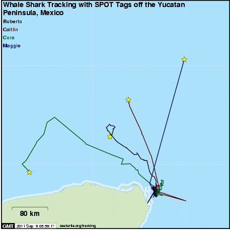
Whale Shark Tracking with SPOT Tags off the Yucatan Peninsula, Mexico
A project of Proyecto Domino in conjunction with the partners and sponsors detailed below.
Subscribe to receive daily project updates
| Name | Species | Life Stage | Release Date | Last Location | Days Transmitted |
|---|---|---|---|---|---|
| Caitlin | Whale Shark | Adult | 2011-07-16 | 2011-09-02 | 48 |
| Cora | Whale Shark | Adult | 2009-08-28 | 2009-09-28 | 31 |
| Maggie | Whale Shark | Adult | 2009-08-29 | 2009-10-26 | 58 |
| Roberto | Whale Shark | Adult | 2011-07-16 | 2011-08-18 | 33 |
Click on an animal's name for maps and more information.
Introduction
 |
The whale shark (Rhincodon typus) is the worldâs largest fish yet it has been rarely studied in the wild. On the east coast of Mexico between mid-April and September each year, whale sharks aggregate in continental shelf waters off Cabo Catoche between Isla Holbox and Isla Contoy, where the northwestern Caribbean Sea meets the southeastern Gulf of Mexico. Since 2003, we have conducted scientific studies of these huge, pelagic plankton-feeders to document their distribution, number, size, sex, behavior and migration. Our team has used research methods comprising a combination of on-water and aerial surveys, feeding studies, tagging and tracking with visual and satellite tags, and logbook data collected by local guides and fishermen. Genetic tissue samples also have been collected for collaborating institutions. The main goal of the project is to reveal the characteristics and importance of the shark aggregations, in order to support management efforts to protect them and their habitat, and to learn more about the basic biology of the whale shark in the wild. These types of information are essential to ensure the sound implementation of conservation plans for the species, including the development of responsible ecotourism.

In 2009, a new experimental tracking study was initiated to follow the movements of two whale sharks using real time satellite tracking technology. This project involved the attachment of SPOT5 tags to the 1st dorsal fin of the sharks. This type of tag has the ability to communicate with Argos satellites whenever the shark is at the surface (and the tag is exposed to air) and ultimately provides us with precise location and movement information.
Project Partners
This tracking work is a component of the research conducted by Proyecto Domino.
It is supported by the Comisión Nacional de Ãreas Naturales Protegidas (CONANP) and is also part of a collaboration with Mote Marine Laboratory's Center for Shark Research.


Project Sponsors
This project has been funded in part by the World Wildlife Fund. The WWF's essential mission is the conservation of nature. Using the best available scientific knowledge and advancing that knowledge where possible, WWF works to preserve the diversity and abundance of life on Earth and the health of ecological systems.
