Satellite Tracking
Why did animal X stop transmitting?
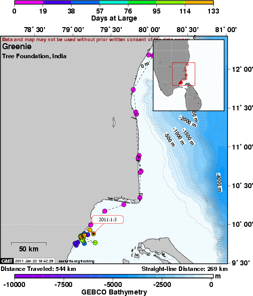
Greenie - Chennai India, olive ridley tracking
A project of Tree Foundation, India.
Static Map | Zoom Map |
Subscribe to Project Updates
Background
Greenie was found on April 20th at Basavan Kuppam fishing village , Marakanam, about 100 km from Neelankarai (TREE Foundation's Rescue and rehabilitation Center). She was found entangled in a fishing net about 8 km from the shore and was very exhausted and did not go back into the sea when released. The village leader Mr Ragu called Dr Supraja Djarini and informend her about the rare beautiful, juvenile turtle around 7 p.m. The TREE Foundation's Stranding team member T Pugalarasu left to Basavan Kuppam by 7.30 and checked the turtle and brought her back to the center by 12.10 midnight. The juvenile green turtle was 43 cm curved carapace length when admitted.
After the necessary permissions from Mr. R Sundararaju I.F.S, the Chief Wildlife Warden, Tamil Nadu the turtle was taken to the Madras Veterinary College and checked for injuries. The X- rays showed that she had no fractures.
After resting well with a daily diet of spinach, romaine lettuce and variety of small fish, freshly brought in by the Sea Turtle Protection Force, she gained weight and seemed ready for release. The turtle's curved carapace length was 49 cm at release. After the necessary permissions from the Ministry of Environment and Forest , the Chief Wildlife Warden Mr R Sundararaju I.F.S gave Dr Supraja Dharini permission to satellite tag the juvenile green turtle. Sirtrack Kiwisat2 juvenile tag was ordered specially for the juvenile turtle.
The satellite tag was placed on the turtle around 11.20 AM on 29th August. Then after the glue completely dried the turtle was gently placed in a 4 feet diameter tank, and taken by a van to Vasavan Kuppam. At Vasavan Kuppam the turtle was placed on a fisherman's boat by Mr. R Sundararaju I.F.S, the Chief Wildlife Warden, Tamil Nadu and Dr Supraja Dharini, Chairperson, TREE Foundation . The TREE Roots & Shoots and Sea Turtle Protection Force volunteers accompanied Greenie on her boat journey back home into the sea. Around 5.15 PM she was gently released into the sea and it was heartening to see her swim away from the boat into the blue sea.
Satellite tags are radio transmitters with GPS that transmit a signal that can be detected by polar orbiting satellites. Depending largely on the number of signals received from an individual tag by a satellite in any given overpass, locations with different levels of accuracy can be assigned. In addition to generating positional information, other data from onboard sensors can also be transmitted, giving information of a range of parameters such as temperature, depth and dive profiles as well as swim speed. Because transmitters can be attached to turtles and the data collected can be recovered by satellite even if the turtle swims hundreds or thousands of kilometers away from where it was released, the technique holds great potential for unlocking many secrets of marine turtle behavior and ecology. These are important tools for spreading awareness to a wide range of people. The outcome of the study will be shared with the Ministry of Environment and Forest and Fisheries.
Green turtles (Chelonia mydas), belong to the Cheloniidae family. Green turtles are the largest of all hard shelled turtles. They can grow up to 100 cms long and weigh about 100 kgs. Their carapace varies in beautiful colors from olive to brown. The under side or the plastron of the turtle is light cream to yellowish in colour. The green turtles can be easily identified as they are the only species of sea turtles that have a single pair of prefrontal scales between their eyes.
These turtles are usually found near sea grass beds, near Islands and coral reef areas as they are predominantly herbivorous. Most of the nesting habitats of green turtles lie within the tropical seas . In India they are found along the coast of Gujarat, Gulf of Mannar, the Islands of Andaman and Nicobar , Lakshwdeep and found feeding in the waters of Tamil Nadu and Andhra Pradesh.
They are found along with manatees or dugongs feeding on sea grass beds. The juveniles feed on a variety of fish and crustaceans and sea grass and algae but as they grow older their diet comprises more of sea grass and algae. They are know to be the grazers or the nursery builders as they crop sea grass and make the area conducive for a variety fish to spawn and grow. They are known as keystone species as their actions in certain sea grass environments can alter the entire structure and dynamics of the whole ecosystem.
The green turtles nest on open sandy beaches and can lay up to 60 to 150 eggs in a clutch and may have a inter nesting interval of 12-15 days and could nest 4-5 times during a season. They take 2-5 years to nest again as they take a longer time to build up the necessary calcium for the eggs to form, since they are largely herbivorous. TREE Foundation hopes to satellite tag a few more Olive Ridley and green turtles in the next year along with the Wildlife Wing of the Forest Department , Tamil Nadu. The data will be compiled and shard with the department of Fisheries in order to help reduce juvenile and adult mortality of sea turtles. T
Tracking objectives:
1-To study the juvenile green turtles that are found feeding in the near shore regions during the months of December to May
2-To reduce unnecessary deaths of adult and juvenile turtles as By catch( non target fisheries)
3-Inform the feeding grounds and congregation paths to the commercial fishermen and request them to lift up their nets every 40 mins or keep away from fishing in those sensitive areas only during the turtle breeding season.
4-To study the migratory paths of green sea turtles for the first time in Chennai, Kancheepuram
The information we are collecting is necessary if we are to protect these amazing species as they Migrate thousands of miles across the oceans, where they encounter industrial and trawl fishing operations, which catch and kills thousands of turtles every year, said Dr. Supraja Dharini
Thanks go to all the print and the Television media for their support and the Chief Wildlife Warden, Mr. R Sundararaju I.F.S. for his inspiration and encouragement to undertake the satellite tagging.
This project is supported by TREE Foundation, The Wildlife Wing of the Forest Department, Tamil Nadu, The Department of Fisheries, Whitley Fund for Nature, UK with logistic assistance from the Sea Turtle Conservation & Research Program at Mote Marine Laboratory, Sarasota Florida.
- The presentation of data here does not constitute publication. All data remain copyright of the project partners. Maps or data on this website may not be used or referenced without the explicit written consent of the data owners.
- For more information please visit the project website.
- This map connects positions generated by the ARGOS system designated as location class (lc) '3', '2', '1', '0', 'A', 'B'. Locations that have been "filtered" are displayed as small red dots.
- This maps also shows locations of class 'Z', 'X' as small black dots which are not connected by a route line.
- Bathymetry layers are derived from the GEBCO One Minute Grid.
- Sea surface temperature and chlorophyll are derived from NASA's Ocean Color data.
- Ocean currents and sea surface heights are derived from AVISO's Ssalto/Duacs Gridded Absolute Dynamic Topography & absolute geostrophic velocities data.
SEATURTLE.ORG collaborates with Argos to help scientists and conservationists manage and analyse their valuable animal tracking data.


|