Satellite Tracking
Why did animal X stop transmitting?
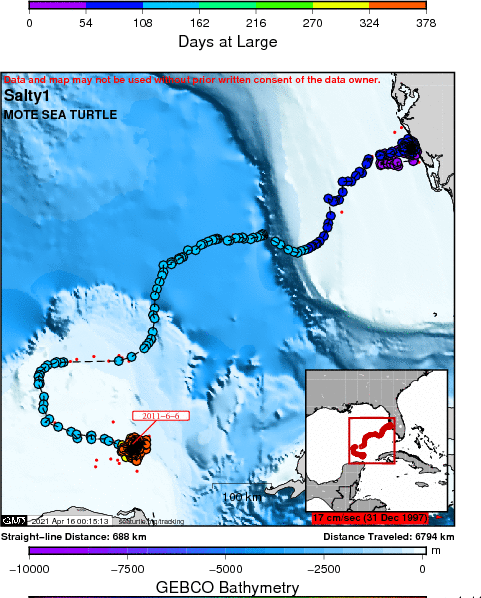
Salty1 - Casey Key Loggerheads 2010
A project of Mote Marine Laboratory.
Static Map | Zoom Map |
Subscribe to Project Updates
Salty (Loggerhead) is 109 km N of the coast of Mexico and 300 km from Merida
Background
Salty is a remigrant turtle, first tagged in 1988, so a known 22 year span of reproductive history. Since loggerheads are thought to mature around 30 years, Salty would be at least 50+ years old. Pretty amazing!
There were few houses at all on Casey Key when Salty was a hatchling, although many houses now line the coast. It is great that most residents keep their lights off for the turtle season (with a gentle reminder from Sarasota County Environmental Services), as Casey Key has the lowest rates of hatchling disorientation for Sarasota County.
Salty measured 104.6 cm curved carapace length, so a pretty big girl who made the plywood corral creak every time she flexed. Salty is sponsored by Wooster School and its Field Studies Program. The program is supervised by Chris Lener, who studies loggerhead epibiota as a predictive method to infer a turtle's home foraging area. There was some neat bioluminescence on Salty's shell and fortunately the thunderclouds stayed away so the students could enjoy the full moon. The Wooster students(Corey, Austin, Grace, and Joey) assisted Salty back to the water and wished her well, what a great way to spend the Memorial Day holiday on a learning expedition.
6/15/10 update. Salty was seen again on a false crawl and we attached a geomagnetic tag and a bioacoustic tag.
- The presentation of data here does not constitute publication. All data remain copyright of the project partners. Maps or data on this website may not be used or referenced without the explicit written consent of the data owners.
- For more information please visit the project website.
- This map connects positions generated by the ARGOS system designated as location class (lc) '3', '2', '1', '0', 'A', 'B'. Locations that have been "filtered" are displayed as small red dots.
- This maps also shows locations of class 'Z', 'X' as small black dots which are not connected by a route line.
- Bathymetry layers are derived from the GEBCO One Minute Grid.
- Sea surface temperature and chlorophyll are derived from NASA's Ocean Color data.
- Ocean currents and sea surface heights are derived from AVISO's Ssalto/Duacs Gridded Absolute Dynamic Topography & absolute geostrophic velocities data.
SEATURTLE.ORG collaborates with Argos to help scientists and conservationists manage and analyse their valuable animal tracking data.


|