Satellite Tracking
Why did animal X stop transmitting?
Annie - Casey Key Loggerheads 2010
A project of Mote Marine Laboratory.
Static Map | Zoom Map |
Subscribe to Project Updates
Annie (Loggerhead) is on the coast of United States and 33 km from St Petersburg
Background
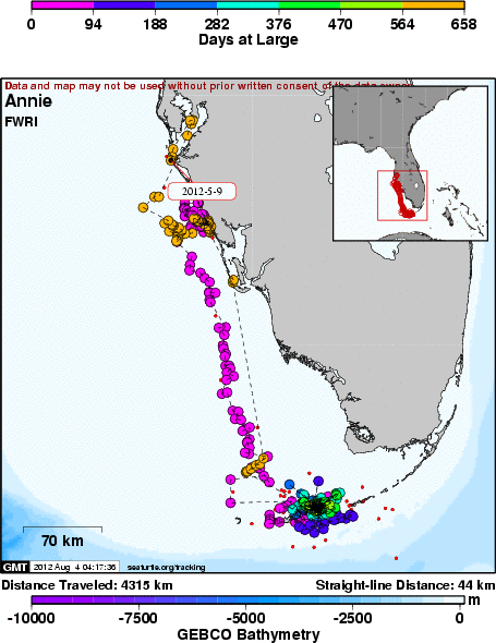
Annie is a small female at 80.3 cm curved carapace length and is a new turtle not previously tagged. Annie bears a depth sensing GPS Fastloc transmitter.
On 24 August 2010, Annie arrived in Niles Channel near Howell Key cove between Summerland Key and Middle Torch Key. Since this locality is just a short boat ride away from the Summerland Key lab of Mote Marine Laboratory, biologists will soon have an opportunity to check in for Annie. Hopefully, Annie stays east of the channel away from boat traffic so that she does not get hit by a speed boat. Florida Fish and Wildlife Conservation Commission compiled statistics that found 1 out of 5 dead or injured loggerheads that wash ashore are bearing injuries from a boat collision (Singel et al 2008). Go slow for those below!
Singel, K., A. Foley, and R Bailey 2008. Navigating Floridaâs Waterways: strandings of marine turtles in Florida. Proceedings of the 27th Annual Symposium on Sea Turtle Biology and Conservation. NOAA Technical Memorandum NMFS-SEFSC-569: 110
2012 activity:
If you were watching loggerhead Annie lately:
4/11 Annie's tag came back on, marked by transmission signals (LC2, 3) that might suggest time at the surface (mating?)
Tag remains in a duty cycle for 24 on/24 hr off so we are left to fill in the blanks by inference every other day.
4/21 had returned to Sarasota Co. vicinity although there were no increased in LC associated with beach proximity that suggested that she's nested yet.
Admittedly that might have happened when the duty cycle was in off mode, and we'd not know.
4/27 had moved offshore and milling about.
It appears clear that she has returned on a 2 yr remigration interval (2010 to 2012) and should nest soon, and its cool to document a first round trip for SW coast of rookery/foraging/rookery.
If we encounter Annie, we want to certainly remove the tag and download the detailed GPS and dive data. We have an Argos receiver to enhance chances of finding her if its near Casey Key. There is also a geomagnetic tag on her so will be a great opportunity to compare tracks by three concurrent methods (GPS/Argos/geomagnetic).
on 6/4/12, Annie came ashore on Manasota Key and made an abandoned egg chamber, she was found on her way back to the water by Howard Berna of Sarasota County Environmental Services who scanned her PIT tag. We hope to see Annie again and recover the tag and download the data.
- The presentation of data here does not constitute publication. All data remain copyright of the project partners. Maps or data on this website may not be used or referenced without the explicit written consent of the data owners.
- For more information please visit the project website.
- This map connects positions generated by the ARGOS system designated as location class (lc) '4', '3', '2', '1', '0', 'A', 'B'. Locations that have been "filtered" are displayed as small red dots.
- This maps also shows locations of class 'A' as small black dots which are not connected by a route line.
- Bathymetry layers are derived from the GEBCO One Minute Grid.
- Sea surface temperature and chlorophyll are derived from NASA's Ocean Color data.
- Ocean currents and sea surface heights are derived from AVISO's Ssalto/Duacs Gridded Absolute Dynamic Topography & absolute geostrophic velocities data.
SEATURTLE.ORG collaborates with Argos to help scientists and conservationists manage and analyse their valuable animal tracking data.


|