Satellite Tracking
Why did animal X stop transmitting?
Withla - Swallow-tailed Kite roost sites, migration, and conservation opportunities
A project of Avian Research and Conservation Inst.
Static Map | Zoom Map |
Subscribe to Project Updates
For more background and details on our Swallow-tailed Kite research, please visit the ARCI website at www.arcinst.org and click on Research.
Background
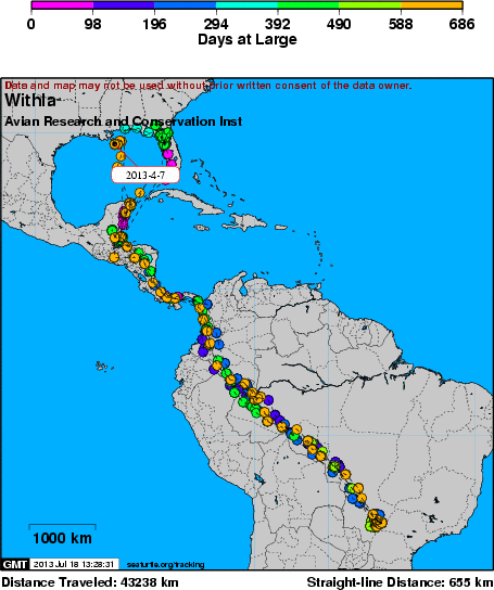
In March of 2013 we noted a very unusual three-week series of large high-pressure systems that produced nearly continuous northerly winds from the southeastern U.S. to the northern Yucatan Peninsula, where the Swallow-tailed Kites stage before their challenging over-water flight back to the U.S. to breed. A few of the kites made it safely to the U.S. Gulf coast before this began, but most waited for the infrequent spells when the strongest headwinds briefly abated, only to encounter stronger, more persistent northerlies once over the Gulf. Withla and 2 of our other 13 GPS-tagged kites (two from Florida, one from South Carolina) did not survive because their lengthy, convoluted flight paths failed to reach the U.S. coast in time (we have learned that this speciesâ over-water limit is about four days).
For more background and details on our Swallow-tailed Kite research, please visit the ARCI website at www.arcinst.org and click on Research.
- The presentation of data here does not constitute publication. All data remain copyright of the project partners. Maps or data on this website may not be used or referenced without the explicit written consent of the data owners.
- For more information please visit the project website.
- This map connects positions generated by the ARGOS system designated as location class (lc) '3', '2', '1'. Locations that have been "filtered" are displayed as small red dots.
- This maps also shows locations of class 'A' as small black dots which are not connected by a route line.
- Bathymetry layers are derived from the GEBCO One Minute Grid.
- Sea surface temperature and chlorophyll are derived from NASA's Ocean Color data.
- Ocean currents and sea surface heights are derived from AVISO's Ssalto/Duacs Gridded Absolute Dynamic Topography & absolute geostrophic velocities data.
SEATURTLE.ORG collaborates with Argos to help scientists and conservationists manage and analyse their valuable animal tracking data.


|