Satellite Tracking
Why did animal X stop transmitting?
Hadi - Renaissance Whale and Dolphin Project 2015 Arabian Sea Humpback Whale Satellite Tagging
A project of Environment Society of Oman.
Static Map | Zoom Map |
Subscribe to Project Updates
Hadi
Background
Hadi OM01-014
âHadiâ is part of a unique population of humpback whales (Megaptera novaeangliae) specifically referred to as Arabian Sea Humpback Whales. This population is understood to be the only non-migratory population of humpback whales in the world. It has been isolated to the Arabian Sea for over 70,000 years, and from studies conducted within Oman less than 100 individuals are thought to exist. The satellite tagging work is considered critical to understand their spatial ecology and mobilise management efforts to ensure their survival.
Hadi was the first whale to be tagged in 2015, and was found singing offshore from Hasik when he was tagged. He was first encountered by the team in 2001 during an autumn survey in the Gulf of Masirah and wasn't re-sighted again until 2012 by âExtra Diversâ staff off the Marriot Hotel in Mirbat. This lead to questions as to where he had been in the intervening years. As such the team is hoping on some new insights as to where this male may spend much of his time. Originally Hadi was named as 'Key-hole' for the distinctive notch in the center of his tail fluke. This year the team have noticed he has lost his keyhole, as they noticed a chunk taken out of this area of his tail which may well be a result of predation.
- The presentation of data here does not constitute publication. All data remain copyright of the project partners. Maps or data on this website may not be used or referenced without the explicit written consent of the data owners.
- For more information please visit the project website.
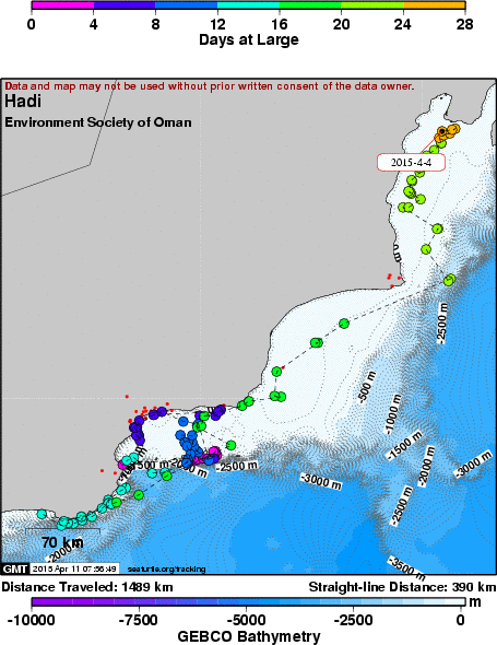
- This map connects positions generated by the ARGOS system designated as location class (lc) '4', '3', '2', '1', 'A', 'B'. Locations that have been "filtered" are displayed as small red dots.
- This maps also shows locations of class '0', 'Z' as small black dots which are not connected by a route line.
- Bathymetry layers are derived from the GEBCO One Minute Grid.
- Sea surface temperature and chlorophyll are derived from NASA's Ocean Color data.
- Ocean currents and sea surface heights are derived from AVISO's Ssalto/Duacs Gridded Absolute Dynamic Topography & absolute geostrophic velocities data.
SEATURTLE.ORG collaborates with Argos to help scientists and conservationists manage and analyse their valuable animal tracking data.


|