Satellite Tracking
Why did animal X stop transmitting?
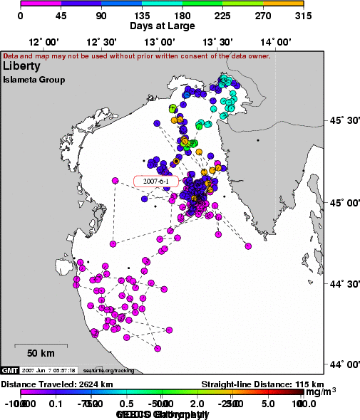
Liberty - AdriaWatch project
A project of Islameta Group, Dept. of Biology - University of Pisa.
Static Map | Zoom Map |
Subscribe to Project Updates
Background
Liberty was found in the Ancona harbour (Eastern Italy) on the 23rd of April 2006 thanks to the Adriawatch partner Protezione civile of Numana. The CCL is about 60 cm and it seems to be developing as a nice girl.
When found she had a serious bacterial infection in the nasal cavity and was treated with antibiotics in the Fondazione Cetacea "Turtle Hospital". After the last check by the two vets, Lara Fichtel and Giordano Nardini, it was decided to release her: healthy and around 20 kg, after 3 months of feeding by hands thanks to the volunteers and being able to catch by herself fishes and squids in the pool, it is time for her to be back in Adriatic sea.
On 22 July, 2006, Liberty was moved to the Rimini harbour and in a wonderful scenario of more than 200 person on 6 boats saying a big �ciao�, she was back in the sea at 18.00 local time.
The release of Liberty is part of the Adria-Watch project (www.adriawatch.provincia.rimini.it). The ADRIA-Watch project is a scientific observatory for large marine vertebrates of the Northern Adriatic Sea. Data are collected and pooled together into one single database, working towards a better understanding and dealing of the problems affecting the large inhabitants of the area and to promote public awareness.
In the framework of this project 5 sea turtles will be released, from five different sites of the northern Adriatic sea, with a satellite transmitter attached. Liberty is one of them.
(Notes by Drs D. Scaravelli and M. Affronte)
- The presentation of data here does not constitute publication. All data remain copyright of the project partners. Maps or data on this website may not be used or referenced without the explicit written consent of the data owners.
- For more information please visit the project website.
- This map connects positions generated by the ARGOS system designated as location class (lc) '3', '2', '1', '0', 'A', 'B'. Locations that have been "filtered" are displayed as small red dots.
- This maps also shows locations of class 'Z', 'X' as small black dots which are not connected by a route line.
- Bathymetry layers are derived from the GEBCO One Minute Grid.
- Sea surface temperature and chlorophyll are derived from NASA's Ocean Color data.
- Ocean currents and sea surface heights are derived from AVISO's Ssalto/Duacs Gridded Absolute Dynamic Topography & absolute geostrophic velocities data.
SEATURTLE.ORG collaborates with Argos to help scientists and conservationists manage and analyse their valuable animal tracking data.


|